
The "Bay Oaks Study" recognized [that] the area on [the] south side of [the] entrance to Dog River on Mobile Bay, the site we called Grand View Park when I was a kid. . . . At that time, on many occasions my family (Mom, Dad, and two brothers and I) would take a picnic and walk out on the long pier and wharf to swim or ride the magic merry-go-round, and try to capture the gold ring (if we did we'd get another trip on the carousel). It was a magical place, and sometimes we'd go under the old Bascule Bridge and fish, not knowing [of] the fact that the 1970s report showed this area to have been Mobile's first port since the bay was shallow. The French had a King's Magazine trading post on the other side of the road, across from Grand View Park, and there was an Indian village on this spot with active trading taking place. There were also shallow draft vessels that would travel, carrying commerce up the bay and up river. This "study" also identified this area as containing many rich and unstudied archeological sites. This was fantastic info and ended up being fantastic ammunition.
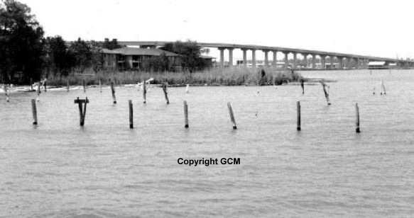
An individual who owned a restaurant on the bay at Dog River Bridge called me and asked if I knew of the proposal to remove the old bridge and build a "high rise one"? He was scared it would put him out of business and asked if I'd look at the state highway plans. I did, and realized that everyone involved in the proposed construction of the high-rise was in violation of state and federal law. The Alabama Historical Commission stated flatly [that] there were no significant archeological sites in the area. This was [an] outright lie. I pulled out the Bay Oak Study and quoted from it [to the effect] that there were significant sites in [the] immediate area and [that] all were violating the law. ----and held press conferences.
Why doesn't Mobile have an urban waterfront park too allow visitors a view of the ships that call at our port, the enjoyment of the bay's breezes or just a place to be able to sit and relax as citizens do in New Orleans, Corpus Christi, Savannah, Charleston, and Baltimore? In Mobile's past, some of the fondest memories by old Mobilians are [of] Arlington Park, Bayfront Road, and Monroe Park. They are now just memories. With proper planning and support it could become a reality.
There was a sort of amusement park there. I remember the carousel more that any thing. Hope someone out there could help me. When I was a child there was a place called Grand View Park on Dauphin Island Parkway..
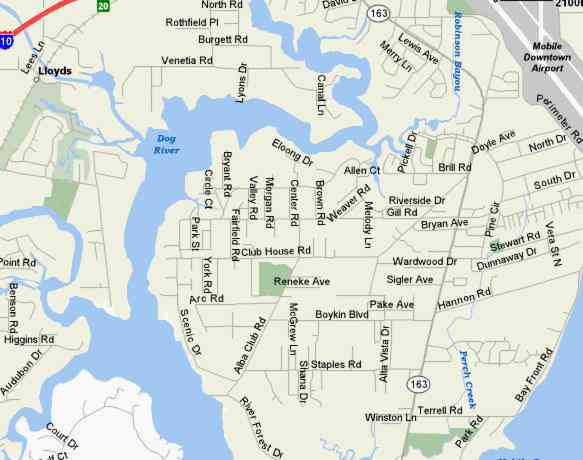
The site is now Harbor Landing Apts. Going south on DIP, just as you cross over Dog River Bridge...It's the first left at the bottom of the bridge.
The Office is built from part of the old carousal, it is round.
I saw some pixs of Grand View somewhere, can't remember where...but I believe it was on line. Maybe you could do a search. I believe the old road was named Point Clear Rd. as there was a ferry that went across the bay to Point Clear and Fairhope, or was it Cedar Point Rd (I forget). You could also take Old Bay Road to get there. I went there as a child many times also. Was great fun and good memories.
I don't have any pictures at this time. I live in California but family lives in the area. There may be photos in our archives but until I retire and move back to Fowl River I do not really have easy access to the archives. (Dad was a internationally known photographer).
As a child I lived walking distance from Grand View Park. It was on Cedar Point Road at the time. That name has been changed to Dauphin Island Parkway. Although we lived on the bayfront and swam and boated from our yard, all us neighborhood children swam at Grand View Park. It was a large park area and a long wharf jutted out into the bay at the mouth of Dog River.
We used to dive off the end which was against the rules as the water was shallow - maybe six feet deep. Some of the boys actually climbed to the roof of the covered area at the end and dove off the roof. What kids will do not knowing their lives are in danger! The location was Hollinger's Island.
Hi - It was Cedar Point Road. and prior to that it was Bay Shell Road. I remember my folks telling me it'd been called "Shell Road".
(P.29 in Images of America Mobile and the Eastern Shore, by Frye, Nancy and Tracy Gaillard, Arcadia Publishing). It's an interesting book, and has several pages devoted to Monroe Park. I remember Grand View Park - watching the monkeys was a hoot.
Hope someone out there could help me. When I was a child there was a place called Grand View Park on Dauphin Island Parkway.
The site is now Harbor Landing Apts. Going south on DIP, just as you cross over Dog River Bridge...It's the first left at the bottom of the bridge.